This stretch of the river, almost 1.5km. long, now runs in
culverts (except for one 40m. exposed section near Pond Hill) and emerges into
the River Don under Castlegate at its junction with Blonk Street (Grid Ref. SK35858773).
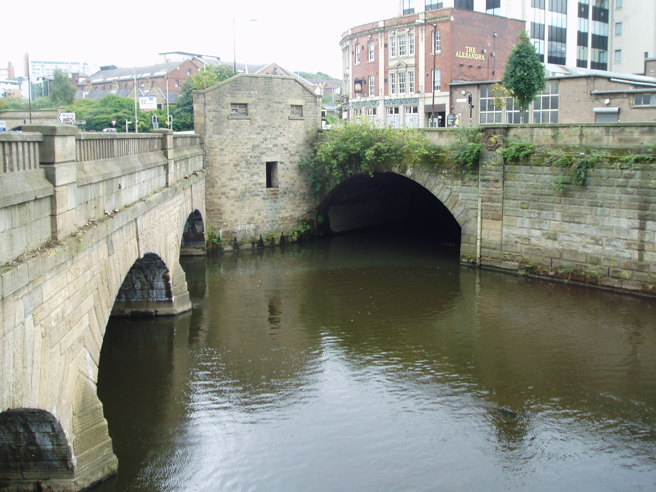 |
| The River Sheaf’s junction with the
Don, the arch on the right, with Blonk Street Bridge, seen on the left. (From Wikipedia) |
But are they still there buried in the culvert? This posting gives a glimpse into some
research I did recently to try and untangle the story of the culvert and to try
and find the old bridges.
The research all started when I was looking into the history
behind a painting in the collection at Museums Sheffield – “The River Sheaf and
Shrewsbury Hospital” - dated to about 1825. The unknown artist had included the Canal Bridge and the, almost
rural, river.
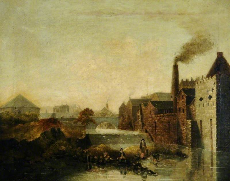 |
| “The River Sheaf andShrewsbury Hospital”, Museums Sheffield - K1930.30 |
My digging quickly led me to lots of excellent photographs of the
culvert – The Megatron – on the internet.
These were in reports of the adventures of Urban Explorers rejoicing in
names such as ‘Snake Oil’, ‘Torchlight’ and ‘Ojay’ – their anonymity reflecting
the ‘unofficial’ nature of their explorations.
Their photographs are a fascinating record of somewhere most
of us will never see (My own days for such adventures are long past – that’s if
they ever existed!) though relating them to the history and to specific
locations were not the photographers priority.
I am grateful to this group of anonymous explorers for recording their
visits, and I hope they will forgive me for using their photographs in this
blog.
With a bit of help from the Sheffield University Speleological Society (link) my first real break came with an email to the Environment Agency
who very kindly sent me a copy of the Structural Report for Culverts ‘230’ and ‘231’
– ‘231’ is the southern/upstream part of the Sheaf Culvert running under the
Midland Station, and ‘230’ is the northern/downstream portion running from Pond
Hill to the River Don at Castlegate. The
reports, plans and sections they provided gave an outline of the structure and
its geography showing how it relates to the modern street layout. My main interest was in the norther section (
Culvert ‘230’), but the information on Culvert ‘231’ could well feature in future
research.
The really big break came through my contacts at Museums
Sheffield. The museum store (where I
‘work’ as a volunteer) includes archives from research done by ARCUS (Archaeological
Research and Consultancy at the University of Sheffield) concerning the site of
Sheffield's Castle Market and Sheaf Market.
This included plans showing the culvert, with detailed heights
for the surface features, the culvert roof and the culvert floor. They only showed part of the northern
culvert, but they did include the area which could include the old Sheaf and
Canal Bridges, and they added valuable detail for the Environment Agency
information.
These sources, taken with the images from the internet, have
allowed me to understand the structure of the culvert and to relate the structure to its
history – and to identify what I believe are the Sheaf and Canal Bridges built
into the structure and still visible (if you know where to look and don’t mind
walking along a rocky river-bed, in pitch black tunnels, ankle deep in water !).

The plan on the right shows the path of the culvert plotted on a
modern map from OpenStreetMap.org (click on this and other images for a better view). The
changes in structure are shown and the separate sections have been labelled AA
through II from Pond Hill to the River Don. These structural changes relate directly to
the phases in the building of the culvert from 1850 to the early 20th
century. (The odd labeling of the sections is mine and evolved
during the research!)
The approximate ‘chainage’ distances along the culvert are
also shown in the plan.
The longitudinal section below shows how the sections of the
culvert relate to the surface features

Note the exaggerated vertical scale to emphasize the
changing height of the culvert. Broken
lines are shown where the heights are less certain
Starting at the upstream, southern end of the culvert, the
sections are ....
AA Under Pond Hill
The start of the culvert is ~10.3m wide by 4.5m high, with vertical concrete walls with stone cladding, supporting concrete roof beams and a concrete slab roof. This section is first seen on the 1905 OS 1:2500 map, though the present structure may be more recent.
 |
| The entrance to section AA of the culvert. (Photo courtesy of the the Environment Agency) |
BB1 Pond Hill to Sheaf Street
The next section consists of three parallel arched tunnels built of brick, each about 3.3m wide and 4m high, and connected by arched openings. This section was built after the 1890 OS 1:500 town plan and before the 1905 map. Previously Pond Hill had not crossed the river but was linked to Sheaf Street by a footbridge – “Dyer’s Bridge”. These tunnels connect to BB2.
 |
| Section BB1 seen from within section AA. (Image by 'Wevsky' http://www.oblivionstate.com/forum/topic/8437-megatron-sheffield-may-2015/) |
This section predates BB1 and AA and is seen as the inlet to the culvert in the 1890 Town Plan - the inlet was then very close to Sheaf Street. This section also consists of three parallel arched tunnels connected by arched openings. These tunnels are about 3.3m wide and 3.3m high, slightly lower than BB1, and are built of stone. BB2 was built to support Sheaf Street which, together with Commercial Street, was built in about 1870 to service the new Midland Station.
 |
| Section BB2 looking upstream toward BB1. (Image by 'Torchlight' https://www.28dayslater.co.uk/megatron-sheffield-april-2017.t108213) |
CC Commercial Street to Broad Street
Under Commercial Street the structure changes slightly in that the three parallel tunnels are no longer connected by arched openings, and also seem to have a brick roof, though this may not apply to its whole length. The change in structure is just south of the modern line of Commercial Street, but closer to the street's position in 1870.
Section CC, which runs from Commercial Street to Broad Street, was built in about 1884 and became the site of an open market for the sale of vegetables and farm produce. Confusingly this market was called the “Sheaf Market”, the name previously applied to the Wholesale Fish Market built in 1879 in a converted Gas Works next to the river. This ‘1884’ Sheaf Market later rejoiced in the name ‘the Rag and Tag Market’. The name was later reused in the 1970 “Sheaf Market” which replaced the Castlefolds Market and has itself now been demolished!!!
The 1884 Sheaf Market can be
seen in the 1890 map and closely follows the old line of the river.
 |
| Inside one of the tunnels of section CC. (Image by Torchlight https://www.28dayslater.co.uk/megatron-sheffield-april-2017.t108213) |
DD Broad Street
The Environment Agency report describes the next part of the culvert as a single masonry arch 10.3m wide by 6m high. In reality it is a series of arches ranging from 4.6 to 6.8m high, and each one reflects its origin – in my notes I have labelled them as DD through GG, and it is here that we find (IMHO!) the remains of the Sheaf and Canal Bridges.
The Environment Agency report describes the next part of the culvert as a single masonry arch 10.3m wide by 6m high. In reality it is a series of arches ranging from 4.6 to 6.8m high, and each one reflects its origin – in my notes I have labelled them as DD through GG, and it is here that we find (IMHO!) the remains of the Sheaf and Canal Bridges.
Section DD is an arch of dressed
stone 4.6m high at its apex, which lies under the old alignment of Broad
Street. Its position and size, and the contrast
between its dressed stone and the rougher masonry of other sections, suggest
that this may be the remains of the original Sheaf Bridge.
Sheaf Bridge was originally a
wooden bridge carrying the road from Sheffield Castle to the Lord of the Manor’s new
Manor House in his deer park (now Manor Lodge).
It was rebuilt in stone in 1596, and had to be rebuilt in 1768 after
being destroyed in a flood (along with part of the old Shrewsbury Hospital). It was widened and realigned in 1821 and this
is probably this bridge which was incorporated into the culvert.
 | |
| The view looking downstream from section CC into section DD showing the dressed stone arch of section DD. (Image by 'Snake Oil' https://www.28dayslater.co.uk/megatron-sheffield-march-2017.t108539) |
 |
| Looking upstream from within sections EE1-4 to the dressed stone arch of section DD, and the end of the three tunnels of section CC. (Image by Xan Asmodi https://www.pinterest.com/pin/335236765982641038/) |
EE1-EE4 Broad Street to Exchange Street
We’ll come back to these sections is a moment, let’s first skip on the section FF ...
FF ~Exchange Street
This section is again an arch of dressed stone which lies south of the present alignment of Exchange Street – BUT this alignment first appeared in the 1923 OS maps. The previous line, as at the time of the original culverting, ran further south close to the position of section FF. Could section FF be the remains of the Canal Bridge? I think there is enough evidence to suggest that it is!
This section is again an arch of dressed stone which lies south of the present alignment of Exchange Street – BUT this alignment first appeared in the 1923 OS maps. The previous line, as at the time of the original culverting, ran further south close to the position of section FF. Could section FF be the remains of the Canal Bridge? I think there is enough evidence to suggest that it is!
The Canal Bridge was built in 1819 to provide a link from Castle Folds to the new Canal Basin. The new roadway ran just to the north of the old Shrewsbury Hospital until this was demolised in 1827 to make way for a new Corn Exchange. The street name then became Exchange Street. Even after the building of the culvert, the 1890 1:500 Town Plan still labels its northern parapet as the Canal Bridge.
 | |
| Looking upstream from within section GG (the parabolic brick arch described below)) through section FF (the high dressed stone arch) and the lower stone arches of EE1-4. Sections DD and CC can be seen in the distance. (Image by 'Snake Oil' https://www.28dayslater.co.uk/megatron-sheffield-march-2017.t108539) |
These arches built in 1850 and were the first stage of the culverting of the river . The ground surface slopes up from Broad Street to Exchange Street (today as in 1850), and the height of the arches reflects this with the height of FF (? the Canal Bridge) being 2.2m higher than section DD (? the Sheaf Bridge).
This culvert created an open
space between Broad Street and Exchange Street which connected the new
‘Norfolk’ Market Hall to the existing Corn Exchange. This became an open market – with a fountain
in the centre! It became a wholesale
fruit and veg market and took on the name “Castlefolds” after the old name for
Exchange Street. By 1878 the Castlefolds
Market had a glass roof and was being extended – part of the same series of
market developments which also saw the creation of the wholesale fish market,
driven in part by increasing demand from the growing town and also by the new
ease of supply by the railways.
GG Exchange Street
This section is perhaps the most spectacular arch in the culvert – it is a 6.7m high parabolic brick arch which lies under the modern alignment of Exchange Street. This alignment first appeared in the 1923 OS maps and by 1935 carried a tram track running up to Blonk Street Bridge. This suggests that the realignment took place between 1905 and 1923, but it is likely to have been done along with the covering of the next part of the river (sections HH and II), probably in about 1914.
The (presumed) Canal Bridge
(section FF) had a height of 6.8m to carry the road from the old Castle Folds
across to the Canal Basin, and the new alignment maintained this height. It is interesting to see that
the roof of this arch is only a metre or so below the pavement of Exchange Street.
 |
| Looking downstream from the dressed stone arch of section FF (possibly / probably the old Canal Bridge) and through the parabolic arch of section GG. (Image by 'Torchlight' https://www.28dayslater.co.uk/one-man-one-dinghy-megatron-sheffield-may-2017.t108499) |
HH Under the old Castle Market site.
Today Exchange Street runs well above the old Castle Market site which has now been cleared following the demolition of the market. Section HH is much lower - at ~3.3m, 3.4m lower than GG, and consists of a flat concrete roof supported by concrete arches. It was built in about 1914.
Section HH includes a concrete weir which replaces a similar structure first mentioned in about 1756 (powering a grinder's wheel first leased in 1731). This holds back an area of standing water which ranges from ankle deep (in section EE1) to thigh deep at the weir.
The concrete of the culvert roof is now beginning to
deteriorate and in places the reinforcing bars have been exposed – the Environment
Agency describe its condition as ‘Poor’.
This is one on the main reasons that plans are now being made to remove
this part of the culvert and create a ‘Pocket Park’ (provisionally called “Sheaf
Fields”) (see link)
II Castlegate
The final section of the culvert runs under Castlegate to the outlet into the River Don. It was (probably) built in about 1916 - that date is seen on the parapet of the culvert outlet - though Castlegate itself was only added in about 1930. In the 1923 OS map there was a small road linking the old Slaughter Houses to Blonk Street Bridge.
Section II is a brick built arch running at a slight angle to Castlegate. In December 1940, during the Sheffield Blitz, a bomb exploded in the mouth of the culvert and what could be shrapnel damage can still be seen in the brickwork.
 |
| The view into section HH from GG. (Image by 'Tochlight' https://www.28dayslater.co.uk/megatron-sheffield-april-2017.t108213) |
 |
| The weir in section HH seen from above. (Image by 'Torchlight' https://www.28dayslater.co.uk/one-man-one-dinghy-megatron-sheffield-may-2017.t108499) |
 |
| 'How deep?' (Image by Salt-Street Productions Ltd. link now seems to be 'dead' https://www.redbull.com/gb-en/wakeboarding-sheffields-underground-storm-drains2) |
 |
| An artist's impression of the proposed 'Sheaf Fields' pocket park. From link. |
The final section of the culvert runs under Castlegate to the outlet into the River Don. It was (probably) built in about 1916 - that date is seen on the parapet of the culvert outlet - though Castlegate itself was only added in about 1930. In the 1923 OS map there was a small road linking the old Slaughter Houses to Blonk Street Bridge.
Section II is a brick built arch running at a slight angle to Castlegate. In December 1940, during the Sheffield Blitz, a bomb exploded in the mouth of the culvert and what could be shrapnel damage can still be seen in the brickwork.
 |
| Looking upstream through section II to section HH and the weir. (Image by 'Torchlight' https://www.28dayslater.co.uk/megatron-from-the-deep-end-april-2017.t108340) |
 | |
| Possible shrapnel damage in section II. (Image by 'Torchlight' https://www.28dayslater.co.uk/megatron-from-the-deep-end-april-2017.t108340) |
 |
| The parapet of the River Sheaf Culvert below Castlegate (the date 1916 can be seen on the right) (Image Picture Sheffield ref. u04625) |
I hope that you have enjoyed this quick (!) trip along the River Sheaf, and thank-you for your patience in reading to the end. As I said earlier, many thanks are due to those whose images I have 'borrowed' - I hope they don't mind. The following are a list of web-pages (in no particular order) that might interest you, some are referenced with the images above, and I'm sure there are many more, just search for 'Megatron Sheffield'.
http://www.shefcavers.org.uk/2014/12/14/drain-of-detritus-dodgy-dvds-death-and-darkness-exploring-the-megatron/
http://www.oblivionstate.com/forum/topic/8437-megatron-sheffield-may-2015/
http://www.oblivionstate.com/forum/topic/8960-megatron-sheffield-june-and-july-2015/
https://www.derelictplaces.co.uk/main/culverts-drains-and-sewers/28730-megatron-sheffield-apr14.html
https://www.28dayslater.co.uk/megatron-sheffield-april-2017.t108213
https://www.28dayslater.co.uk/megatron-sheffield-march-2017.t108539
https://www.28dayslater.co.uk/megatron-sheffield-2016.t107122https://www.28dayslater.co.uk/megatron-sheffield-august-2014.t91737
https://www.28dayslater.co.uk/megatron-sheffield-august-2015.t98961
https://www.28dayslater.co.uk/megatron-sheffield-june-and-july-2015.t97955
https://www.28dayslater.co.uk/megatron-sheffield-march-2017.t107947
https://www.28dayslater.co.uk/megatron-sheffield-march-2017.t107862
https://www.28dayslater.co.uk/megatron-sheffield-september-2015.t101675
http://www.coffeewithanarchitect.com/2011/04/15/architecture-week-day-6-undercity-photography/ (includes other locations)
No comments:
Post a Comment